Near Surface Silver Mineralization Intercepted in 190 out of total 195 holes;
Numerous Significant Intercepts include 99.91 metres grading 244 g/t Ag
VANCOUVER, British Columbia – February 20, 2019 — New Pacific Metals Corp. (TSX-V:NUAG) (OTCQX:NUPMF) (“New Pacific” or the “Company”) is pleased to announce the second batch of drill results from its wholly-owned Silver Sand Project in Potosí Department, Bolivia.
As announced previously on the Company’s news release dated January 22, 2019, the drilling program commenced in mid-October 2017. A total of 55,010 metres in 195 HQ size diamond core drill holes had been completed by mid-December 2018. The drill program covers an area of approximately 1,600 m long in the north-south direction and up to 800 m wide in the east-west direction. The holes were drilled along northeast 60 degree oriented sections with a 50 m spacing between the sections. Most drill holes are drilled at a dip angle of 45 degrees to penetrate the principal trend of the mineralized structure zones with an average hole length of approximately 285 m. The results for the first batch of 98 drill holes were released on January 22, 2019. This news release discloses the assay results of the remaining 97 holes, of which 96 holes intercepted silver mineralization. These 97 holes were drilled mainly to the north of the section 60 covering an area of approximately 1,100 m long north-south and 800 m wide in the east-west direction.
Highlights of significant drill intersections are summarized as follows (for a detailed list, please refer to Table-1 – Composited Drill Intersections of Mineralization below):
· Drill hole DSS505003, 225.82m @ 116g/t Ag from 59.85m to 285.67m,
incl. 99.91m @ 244g/t Ag from 185.76m to 285.67m;
· Drill hole DSS5203, 6.41m @ 290g/t Ag from 21.09m to 27.5m, and
192.93m @ 123g/t Ag from 100.77m to 293.7m,
incl. 17.43m @ 329g/t Ag from 100.77m to 118.2m, and
incl. 74.06m @ 191g/t Ag from 219.64m to 293.7m;
· Drill hole DSS505004, 95.2m @ 162g/t Ag from 73.5m to 168.7m,
incl. 16.7m @ 703g/t Ag from 117.7m to 134.4m, and
incl. 7.30m @ 291g/t Ag from 161.4m to 168.7m;
· Drill hole DSS4402, 144.85m @ 86g/t Ag from 69.85m to 214.7m,
incl. 48.5m @ 211g/t Ag from 129.5m to 178.0m
· Drill hole DSS5604, 79.48m @ 135g/t Ag from 39.92m to 119.4m,
incl. 22.73m @ 330g/t Ag from 39.92m to 62.65m;
· Drill hole DSS425001, 118.46m @ 88g/t Ag from 63.18m to 181.64m,
incl. 15.14m @ 244g/t Ag from 63.18m to 78.32m, and
incl. 17.27m @ 333g/t Ag from 85.88m to 101.15m;
· Drill hole DSS4204, 68.4m @ 148g/t Ag from 86.6m to 155.0m;
· Drill hole DSS425002, 35.86m @ 277g/t Ag from 97.23m to 133.09m;
· Drill hole DSS5204, 12.56m @ 119g/t Ag from 62.5m to 75.06m, and
12.7m @ 261g/t Ag from 110.71m to 123.41m, and
39.62m @ 116g/t Ag from 180.73m to 220.35m;
· Drill hole DSS5411, 192.5m @ 50g/t Ag from 4.5m to 197.0,
incl. 1.25m @ 1865g/t Ag from 18.75m to 20.0m;
· Drill hole DSS565003, 63.27m @ 141g/t Ag from 21.95m to 85.22m;
· Drill hole DSS5408, 114.64m @ 76g/t Ag from 18.36m to 133.0m,
incl. 2.0m @ 2099g/t Ag from 131.0m to 133.0m;
· Drill hole DSS4609, 83.92m @ 103g/t Ag from 63.38m to 147.3m,
incl. 10.4m @ 398g/t Ag from 84.3m to 94.7m, and
incl. 8.9m @ 414g/t Ag from 138.4m to 147.3m;
· Drill hole DSS5201, 123.7m @ 64g/t Ag from 79.6m to 203.3m,
incl. 26.85m @ 135g/t Ag from 85.15m to 112.0m, and
incl. 7.65m @ 201g/t Ag from 124.7m to 132.35m;
· Drill hole DSS505001, 124.02m @ 63g/t Ag from 60.9m to 184.92m,
incl. 32.65m @ 116g/t Ag from 60.9m to 93.55m;
· Drill hole DSS445001, 99.61m @ 75g/t Ag from 95.82m to 195.43m
incl. 10.41m @ 199g/t Ag from 151.46m to 161.87m, and
incl. 2.0m @ 1930g/t Ag from 193.43m to 195.43m;
· Drill hole DSS5807, 48.63m @ 148g/t Ag from 7.0m to 55.63m;
· Drill hole DSS545003, 84.06m @ 80g/t Ag from 37.24m to 121.3m,
incl. 17.15m @ 172g/t Ag from 37.24m to 54.39m, and
incl. 18.7m @ 174g/t Ag from 102.6m to 121.3m;
· Drill hole DSS485004, 116.15m @ 53g/t Ag from 54.43m to 170.58m,
incl. 23.57m @ 152g/t Ag from 54.43m to 78.0m, and
· Drill hole DSS5210, 143.74m @ 39g/t Ag from 70.84m to 214.58m,
incl. 3.69m @ 1190g/t Ag from 70.84m to 74.53m;
· Drill hole DSS405002, 47.24m @ 117g/t Ag from 99.22m to 146.46m
· Drill hole DSS5006, 140.51m @ 39g/t Ag from 23.18m to 163.69m,
incl. 4.07m @ 343g/t Ag from 89.38m to 93.45m;
· Drill hole DSS545002, 68.67m @ 79g/t Ag from 13.1m to 81.77m;
· Drill hole DSS5207, 93.02m @ 55g/t Ag from 56.19m to 147.78m,
incl. 6.0m @ 266g/t Ag from 129.88m to 135.88m, and
incl. 4.93m @ 256g/t Ag from 142.85m to 147.78m;
· Drill hole DSS505005, 33.47m @ 141g/t Ag from 31.83m to 65.3m;
· Drill hole DSS465001, 36.38m @ 117g/t Ag from 70.39m to 106.77m,
incl. 17.36m @ 212g/t Ag from 70.39m 87.75m;
· Drill hole DSS5001, 15.16m @ 152g/t Ag from 104.4m to 119.56m, and
16.2m @ 119g/t Ag from 196.1m to 197.23m;
· Drill hole DSS5002, 13.65m @ 308g/t Ag from 262.1m to 275.75m;
· Drill hole DSS5208, 48.25m @ 87g/t Ag from 64.5m to 112.75m,
incl. 28.0m @ 110g/t Ag from 64.5m to 92.5m;
· Drill hole DSS425003, 35.2m @ 118g/t Ag from 200.7m to 235.9m;
· Drill hole DSS465005, 59.75m @ 69g/t Ag from 64.25m to 124.0m,
incl. 24.15m @ 154g/t Ag from 99.85m to 124.0m;
· Drill hole DSS505008, 35.15m @ 117g/t Ag from 90.0m to 125.15;
· Drill hole DSS5608, 9.31m @ 423g/t Ag from 76.0m to 85.31m;
· Drill hole DSS5007, 53.35m @ 66g/t Ag from 89.39m to 142.74m, and
25.1m @ 261g/t Ag from 273.7m to 298.9m;
· Drill hole DSS5402, 63.6m @ 49g/t Ag from 141.4m to 205.5m,
(True width of mineralization zones is estimated at about 80% of drill intervals based on current understanding of the relationship between drill direction and the mineralized structures. Please refer to Table-1 – Composited Drill Intersections of Mineralization below for details.)
Based on the drilling results, the drill holes usually penetrate first through a few metres up to more than 70 m thick layer of reddish siltstone and mudstone units of Cretaceous Tarapaya Formation, then into massive altered white colour arenites or sandstones units of the Cretaceous La Puerta Formation where silver mineralization is hosted. At the contact of these two units, massive or densely disseminated pyrite mineralization of a few metres wide in thickness typically occurs. Tin mineralization in the district is often associated with massive pyrite, locally called “Bolivia manto type of tin mineralization”. At depth, many drill holes end at the unaltered reddish sandstone units of the Cretaceous La Puerta Formation. The Cretaceous Formations sit unconformably on a basement of tightly folded and faulted Paleozoic marine clastic sediments.
The mineralized sandstone and siltstone units of the Cretaceous Formations are shallow dipping or sub-horizontal and gently folded into open synclines and anticlines with their hinges shallowly plunging to North-North-West (“NNW”) direction. To the north of Silver Sand Project, numerous porphyrytic dacitic sills and dykes of Miocene age intrude and cut the Cretaceous sediments which are believed to be closely associated with silver mineralization in the district.
Silver mineralization is observed to be associated with fractures as sheeted veins, stockwork veinlets, crackle veins and breccia zones of sulfosalts and sulfides containing silver (Figure-1) in altered sandstones units which were bleached white due to sericite alteration of original reddish sandstones resulting in a sub-horizontal mineralized zone of up to more than 200 m in thickness beneath the Tarapaya red siltstone and mudstone (Figure-2). The most common silver-containing sulfosalt is freibergite associated with small amounts of miargyrite, polybasite, bournonite, boulangerite, andorite and bismuthinite.
The mineralized fractures generally extend NNW sub-vertically and slightly dipping west. The mineralized bodies within the Silver Sand Project were detected by drilling within an area of up to 1,600 m long in north-south direction and 800 m wide in east-west direction within the property limit and remain open to both the north and the west. Mineralized bodies were oxidized to various extents to depth and could extend from near surface to a depth of up to more than 250 m.
2019 Drilling Program
Assay results of surface sampling of hundreds of artisanal mining dumps and continuous chip-sampling from artisanal underground mining tunnels reveal the silver mineralized fracture zones could extend at least by 3,000 m to the north and 500 m to the west and the east, as well as extending up to 1,000 m to the south of the areas drilled in 2018. These newly identified extensions of the mineralized fracture zones will be the targets of the continuing drilling program in 2019 once the rainy season ends by the end of March.
In addition, the Company is currently applying for permits to drill the areas covered under the Mining Production Contract (“MPC”) executed with COMIBOL in January 2019. The drilling program for the MPC areas will commence once the drilling permits are granted by local authorities in two to three months.
Quality Assurance and Quality Control
HQ size drill core samples from altered and mineralized intervals were split into halves by diamond saw cutting with an average sample interval of one to one and half metres long at the Company’s core processing facility located in Betanzos, a local town 20 km away from the project site. Half core samples are stored in secured core storages for future reference and the other half core samples are shipped in security sealed bags to ALS Global in Oruro, Bolivia for preparation, and ALS Global in Lima, Peru for geochemical analysis with the code of OG46 for elements of silver, lead and zinc. Silver overlimits further go to gravimetric analysis with the code of GRA21.
A standard quality assurance and quality control (“QAQC”) protocol is employed to monitor the quality of sample preparation and analysis. Standards of certified reference materials, blanks and duplicates are inserted in normal core sample sequences prior to shipment to lab at a ratio of 20:1 (i.e., every 20 samples contain at least one standard sample, one blank sample, and one duplicate sample). The assay results of QAQC samples did not show any significant bias of analysis or contamination during sample preparation.
Technical information contained in this news release with respect to New Pacific has been reviewed and approved by Alex Zhang, P.Geo., Vice President of Exploration, who is a Qualified Person for the purposes of National Instrument 43-101 – Standards of Disclosure for Mineral Projects (“NI 43-101”).
ABOUT NEW PACIFIC
New Pacific is a Canadian exploration and development company which owns the Silver Sand Project in Potosí, Bolivia. The Company is actively carrying out drilling activities at the Silver Sand Project and is looking for acquisition opportunities in Bolivia. The Company’s non-active assets include the Tagish Lake gold project in Yukon, Canada and the RZY Project in Qinghai Province, China. The Company’s largest shareholders are Silvercorp Metals Inc. (TSX/NYSE American: SVM) and Pan American Silver Corp. (TSX/NASDAQ: PAAS), one of the world’s largest primary silver producers, which operates six mines, including the San Vicente mine located in Potosí, Bolivia. Pan American Silver Corp. became a shareholder of the Company in 2017.
For further information, contact:
New Pacific Metals Corp.
Gordon Neal
President
Phone: (604) 633-1368
Fax: (604) 669-9387
info@newpacificmetals.com
www.newpacificmetals.com
Neither the TSX Venture Exchange nor its Regulation Services Provider (as that term is defined in the policies of the TSX Venture Exchange) accepts responsibility for the adequacy or accuracy of this news release.
CAUTIONARY NOTE REGARDING FORWARD-LOOKING INFORMATION
Certain of the statements and information in this press release constitute “forward-looking information” within the meaning of applicable Canadian provincial securities laws. Any statements or information that express or involve discussions with respect to predictions, expectations, beliefs, plans, projections, objectives, assumptions or future events or performance (often, but not always, using words or phrases such as “expects”, “is expected”, “anticipates”, “believes”, “plans”, “projects”, “estimates”, “assumes”, “intends”, “strategies”, “targets”, “goals”, “forecasts”, “objectives”, “budgets”, “schedules”, “potential” or variations thereof or stating that certain actions, events or results “may”, “could”, “would”, “might” or “will” be taken, occur or be achieved, or the negative of any of these terms and similar expressions) are not statements of historical fact and may be forward-looking statements or information.
Forward-looking statements or information are subject to a variety of known and unknown risks, uncertainties and other factors that could cause actual events or results to differ from those reflected in the forward-looking statements or information, including, without limitation, risks relating to: fluctuating equity prices, bond prices, commodity prices; calculation of resources, reserves and mineralization, foreign exchange risks, interest rate risk, foreign investment risk; loss of key personnel; conflicts of interest; dependence on management and others.
This list is not exhaustive of the factors that may affect any of the Company’s forward-looking statements or information. Forward-looking statements or information are statements about the future and are inherently uncertain, and actual achievements of the Company or other future events or conditions may differ materially from those reflected in the forward-looking statements or information due to a variety of risks, uncertainties and other factors, including, without limitation, those referred to in the Company’s Annual Information Form for the year ended June 30, 2018 under the heading “Risk Factors”. Although the Company has attempted to identify important factors that could cause actual results to differ materially, there may be other factors that cause results not to be as anticipated, estimated, described or intended. Accordingly, readers should not place undue reliance on forward-looking statements or information.
The Company’s forward-looking statements or information are based on the assumptions, beliefs, expectations and opinions of management as of the date of this press release, and other than as required by applicable securities laws, the Company does not assume any obligation to update forward-looking statements or information if circumstances or management’s assumptions, beliefs, expectations or opinions should change, or changes in any other events affecting such statements or information. For the reasons set forth above, investors should not place undue reliance on forward-looking statements or information.
CAUTIONARY NOTE TO US INVESTORS
This news release has been prepared in accordance with the requirements of NI 43-101 and the Canadian Institute of Mining, Metallurgy and Petroleum Definition Standards, which differ from the requirements of U.S. Securities laws. NI 43-101 is a rule developed by the Canadian Securities Administrators that establishes standards for all public disclosure an issuer makes of scientific and technical information concerning mineral projects.
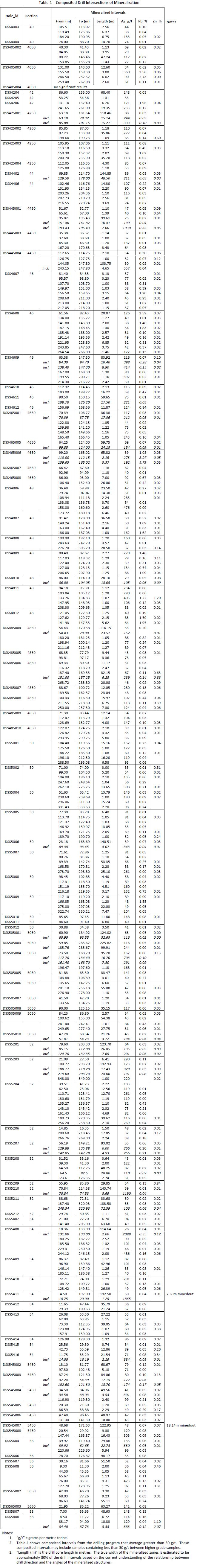
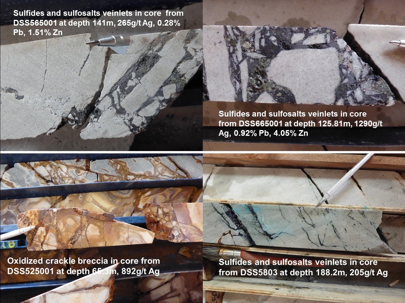
Figure-1
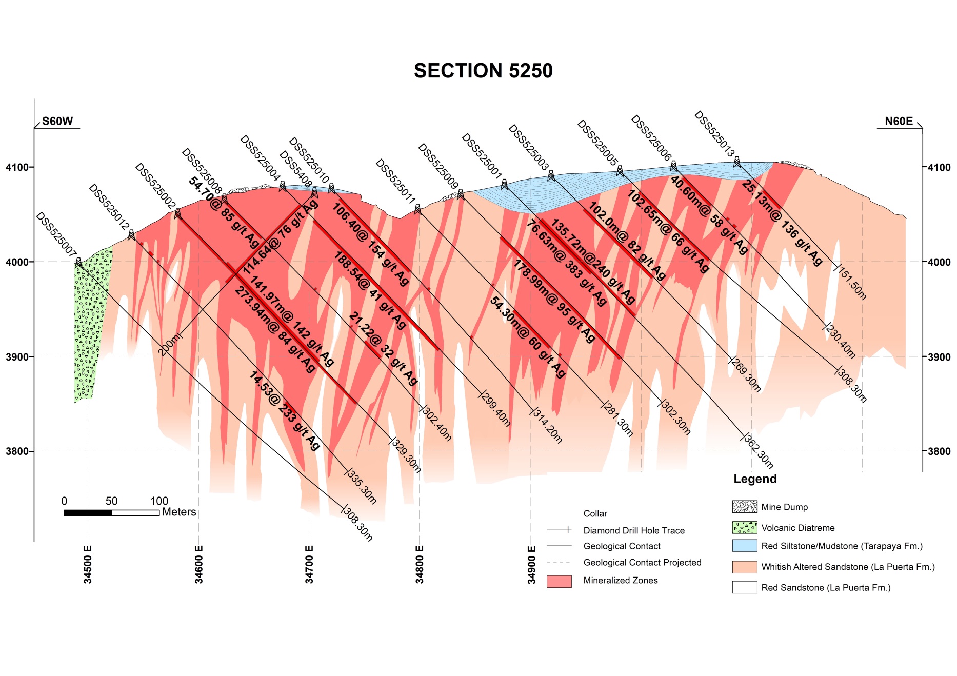
Figure-2