Vancouver, British Columbia (January 13, 2011) – New Pacific Metals Corp. (“New Pacific”, TSX-V:NUX) announces findings from its re-evaluation and reassessment of historical exploration and drilling results at the Goddell Project on the Tagish Lake Gold Property, Yukon Territory, Canada (the “Goddell Project”). The Tagish Lake Gold Property consists of 178 square kilometres of mineral claims and is located approximately 80 kilometres by road from Whitehorse, Yukon Territory.
The Goddell Project is located on the east side of the Tagish Lake Gold Property. Prior to 1996, a total of 9,261 metres of surface drilling in 30 holes had been drilled at the Goddell Project. In 1996, an approximately 780 metre long, 3.5 metre by 4.0 metre decline was developed from the surface at the 1,015-metre elevation to provide access for underground drilling. By 1997, a total of 9,242 metres of underground drilling in 40 holes was completed. In 2003, Tagish Lake Gold Corp. (now, a 100% subsidiary of New Pacific) completed two surface drill holes totalling 975 metres, and in the following year two holes totalling 900 metres were drilled near the decline as part of a Yukon Government training program.
Data Review of Goddell Project
Gold mineralization at the Goddell Project occurs along the east-west trending Goddell Fault (shear zone) developed in a quartz monzonite intrusion of Cretaceous age. The Goddell Gully Zone (“G.G. Zone”) gold mineralization was discovered by surface mapping, chip sampling and trenching. In 1987, 11 shallow surface holes totalling 2,854 metres were drilled into the G.G. Zone from approximately 1,280-metres elevation down to 900-metres elevation; the best interval included 10.9 metres of 2.23 g/t gold in a rhyolite dyke. Drilling in 1988 tested deeper, to 800-metres elevation, and intercepted 11.24 metres grading 20.91 g/t gold, also in a rhyolite dyke. This new gold zone was referred as the “P.D. Zone”. In 1997, 37 underground drill holes totalling 8,520 metres were drilled to explore the P.D. Zone over a 400 metre strike length and a vertical extent of 170 metres, from approximately 870-metre elevation down to 700-metre elevation.
The geological relationship between the G.G. Zone and the P.D. Zone was not fully understood until 2003, when a structural analysis and alteration study was carried out on drill core. The G.G. Zone gold mineralization is developed along a rhyolite dyke (called “North Rhyolite Dyke”) that outcrops in Goddell Gully, where it became the focus of exploration. Gold mineralization in the P.D. Zone appears to have developed along a second rhyolite dyke (called “South Rhyolite Dyke”) that was intersected by drilling south of the G.G. Zone dyke, but was not reported to have been found at surface.
In 2003, Tagish Lake Gold Corp. re-sampled core from two surface drill holes and thirty-four underground drill holes. A total of 801 new samples were taken because the previous sampling program had not sampled continuously between many high grade intervals. From this re-sampling program, it was observed that higher grade gold intervals occur near the contacts between the rhyolite dykes and quartz monzonite, and low to moderate grade gold mineralization occurs between high grade gold intervals in the rhyolite dyke (2003 Technical Report by CME Consulting Ltd.). This re-sampling program also revealed a number of new gold mineralized intervals.
Recently, New Pacific’s technical team has re-examined the assay results from all available historical Goddell Project drill holes. The team determined that many drill core sample intervals start from or end in mineralization, indicating that the 2003 resampling program was still incomplete; accordingly, further sampling of these historical drill cores is warranted.
New Pacific Corp. has also re-plotted all drill hole cross-sections from the Goddell Project for the first time, extending the sections from the 600-metre elevation level (that is, at depth) to the surface (at 1,600-metres elevation). Based on this work, the team has re-interpreted the geology and produced a new geological model for the Goddell Project. The cross-sections show that the G.G. Zone (the North Rhyolite Dyke) outcrops in Goddell Gully (valley) dipping steeply to the north at about 85 degrees. The up-dip projection of the P.D. Zone (the South Rhyolite Dyke) to the surface is at the top of the hill at a location approximately 250 metres above and 400 metres south of Goddell Gully or the G.G. Zone. The P.D. Zone dips to the north at about 65 degrees. As a result of their proximity and contrasting dip angles, New Pacific now believes that the steeply dipping G.G. Zone and the less steeply dipping P.D. Zone merge at depth.
Endorsing this re-interpretation, near Exploration Line 4410E, the G.G. Zone outcrops at approximately 1,320-metres elevation, merging into the PD Zone near 800-metres elevation, approximately 520 metres below surface (see New Pacific website for the drill plan map, cross-section, and 3D model). Where the two zones merge, gold mineralization intensifies, yielding thicker mineralized intervals (the “Merged Zone” or P.D. Zone) as displayed in Table 1. The Merged Zone plunges at about 45 degrees to the west, and for this reason many historical drill holes located west of Line 4410E may not have been drilled deep enough to intersect the Merged Zone, hitting only the G.G. Zone.
Re-Calculation of Drill Intervals for the Merged Zone or P.D. Zone
Based on this new geological interpretation, it is now believed that only three surface holes and 26 underground holes intercepted the Merged Zone, and only one surface drill hole (90-GT6) intercepted the up-dip extension of the P.D. Zone (Table 1). The assay intervals for these 30 drill holes were thus re-calculated and listed in Table 1. The most significant recalculated intercepts for the Merged Zone or P.D. Zone are:
� Drill hole 97-41 intercepted 64.69 metres grading 5.75 g/t gold;
� Drill hole 88-PG3 intercepted 42.4 metres grading 6.23 g/t gold;
� Drill hole 97-59 intercepted 32.8 metres grading 7.94 g/t gold; and
� Drill hole 97-35 intercepted 31.7 metres grading 5.59 g/t gold.
The 2011 surface and underground drill program will test this new model by drilling down plunge and down dip of the Merged Zone, and into the projected up-dip extension and surface outcrop of the P.D. Zone.
Table 1: Comparisons of Drill Intervals for the P.D. Zone
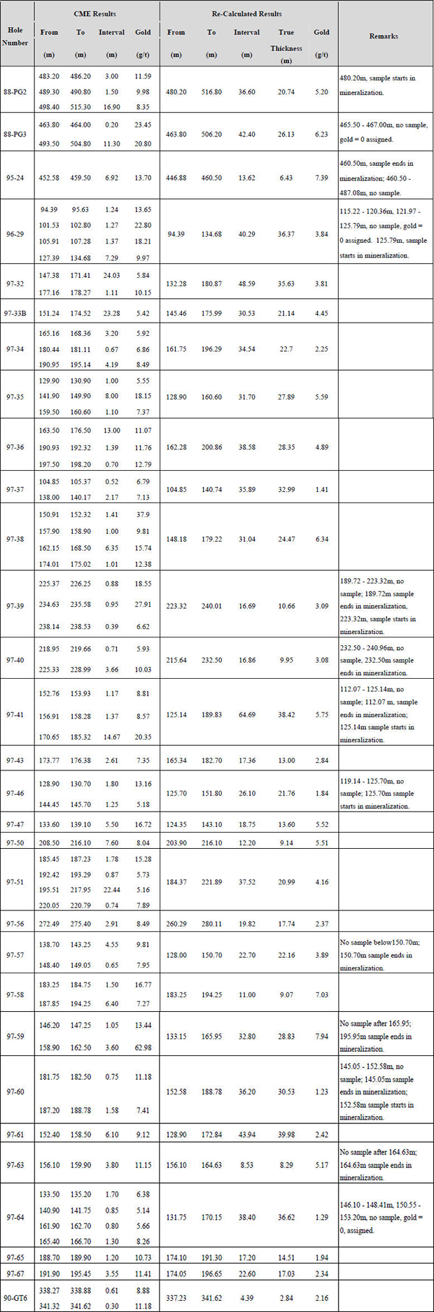
Note: The “CME Results” were calculated using a 4 g/t gold cut-off whereas the “Re-Calculated Results” were calculated using a 0.5 g/t gold cut-off.
Gerhard Jacob is the Qualified Person for the project pursuant to National Instrument 43-101. He has reviewed this news release and verified re-calculation of the intervals as set out in Table1.
About New Pacific Metals Corp.
New Pacific is engaged in the exploration and development of mineral resources in Canada and China. The Company’s strategy is to focus on projects that it believes can be developed in a relatively short time frame into high-margin operations with reasonable development capital profiles. Its goal is to get projects into production with sufficient initial resources, but before the full resource potential of the properties are defined, so that later exploration and potential development costs can be funded by cash flows generated from early operations.
For Further Information:
New Pacific Metals Corp.
Investor Relations
Phone: +1 (604) 633-1368
Fax: +1 (604) 669-9387
Email: info@newpacificmetals.com
Website: www.newpacificmetals.com
Neither TSX Venture Exchange nor its Regulation Services Provider (as that term is defined in policies of the TSX Venture Exchange) accepts responsibility for the adequacy or accuracy of this release.